

Extracting the NDVI satellite image values of arable land
Making the biomass analysis for arable land possible
-
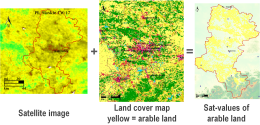 Extracting arable land NDVI values
The aim of the extraction process is to provide information on the biomass development of the field crops to be analysed over a particular period according to the customer indication.
In a first step the areas located within the administrative boundaries for which official agricultural statistics are available are cut out of the pre-processed satellite image week or decade composites. Here, any area can be considered.
In a next step, these areas are overlaid with spatial land use information. That way, the arable land is identified as reference surface.
After that, the reference surfaces are mixed with the satellite image composites. This often produces thousands of polygons representing the satellite image values of, for example, the entire arable land of the region.
This extraction process is repeated for each week or each decade of the period to be analysed and average values are calculated. The process chain is automated to a large extent and its quality assured by experts at different control points. On this basis, agronomists with long years of scientific expertise assess the results, analyse and interpret these and summarise them in an understandable manner through pictures, graphs and tables within a Site Similarity Certificate.


